Classes:
PR
Date:
Sun 28 Jul 2019
Location:
Glenariff Forest Park, 98 Glenariff Road BT44 0QX
Click for Map
Branch/
Organiser:
Ulster
Name: Gail Baillie
M: 079 0382 6800
T: 028 2827 8009
A: 30 Tureagh Road, 30 Tureagh Road, Larne, Co Antrim, BT40 3NH
Enter:
More Details:
Sorry due to the conditions on some of the tracks we have decided not to run this ride as a CTR. Pleasure Rides ONLY
All riders welcome to Glenariff Forest situated in the world famous Glens of Antrim. On a fine day there is splendid views in this magnificent Antrim Plateau setting. Really a brilliant ride for all.
Starts 10.00am - last horse out 1.00pm
Riders have a choice of 2 courses - 8 miles (approx) or the longer 11 mile (approx) track. No need to make your mind up yet, the course will be clearly marked where the 11 mile route branches off. You can make up your mind then about the distance you wish to ride.
Open to non-members.
Directions
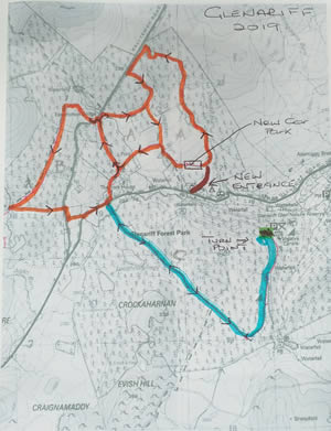
Glenariff 2019
This year’s ride takes place from the newly designated Horsebox Parking Area at Glenariff Forest Park which is located some distance from the main car park and cafe area. There are 3 water taps, but NO toilet facilities.
Directions:- DO NOT USE MAIN FOREST PARK ENTRANCE
ROUTE: There are 3 route options:-
Please take extreme care when riding any of the road sections or crossings.
Map